Rivals of Massachusetts Governor Elbridge Gerry coined the term, “gerrymandering”, in 1812 to describe a Gerry-spawned district that looked rather salamander-like, and that turned out to be quite politically advantageous to Mr. Gerry. The word has been applied ever since to wiggly and manipulated redistricting efforts that go beyond the legitimate geometric gymnastics required to even out population counts and provide racial balance.
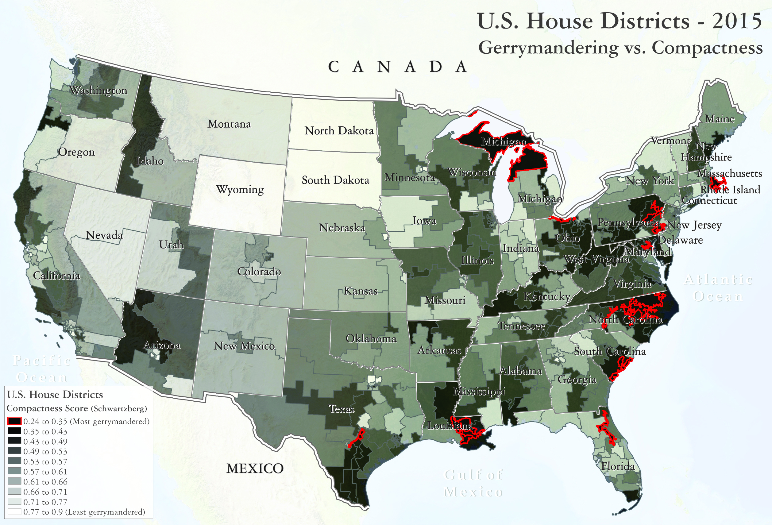
Concerns about gerrymandering have grown in recent years, although the courts have remained reluctant to intervene (Abbott v. Perez, Benisek v. Lamone, Gill v. Whitford). Using powerful computers, sophisticated software, and reams of polling data, it is possible now to draw districts that “pack” (in other words, cluster and bunch) a dominant party’s votes, and “crack” (that is, break up and disperse) a challenging party’s votes. In effect, candidates are coming closer to choosing their favorite voters, rather than the other way around! This can frustrate political efforts, such as conservation work, that are popular among the electorate, but less so among party officials in charge of mapping out district boundaries.
Texas is not immune. Critics charged that several Texas state and federal districts created after the 2010 census were too “non-compact”, too “non-contiguous” to pass muster. They were seen as having been gerrymandered by a Republican-dominated Legislature in favor of their fellow Republican candidates. Traditionally these were hard charges to make stick. Gerrymandering was long considered to be too subjective, like Rorschach inkblot reading, for plaintiffs to successfully challenge in court.
Yet, recent formulas for measuring “compactness” can help make refereeing these district boundaries more objective. The formulas (including the one shown here, developed by J.E. Schwartzberg, as well as others put together by Daniel Polsby and Robert Popper) basically compare how efficiently a district’s shape contains a given area, using the smallest possible perimeter (the ideal would be provided by a circular district).
Using this approach, federal House district 35 (stretching from Austin to San Antonio), as well as a variety of others in Texas’ fellow states, look suspiciously non-compact, and quite salamander-like.
Sources:
Azavea. 2009. Redrawing the Map on Redistricting 2010: A National Study. Philadelphia, Pennsylvania.
Azavea. 2012. Redrawing the Map on Redistricting 2012: Addendum. Philadelphia, Pennsylvania.
Chambers, Christopher and Alan Miller. 2010. “A Measure of Bizarreness”, in Quarterly Journal of Political Science, Vol. 5, No. 1, pp. 27-44.