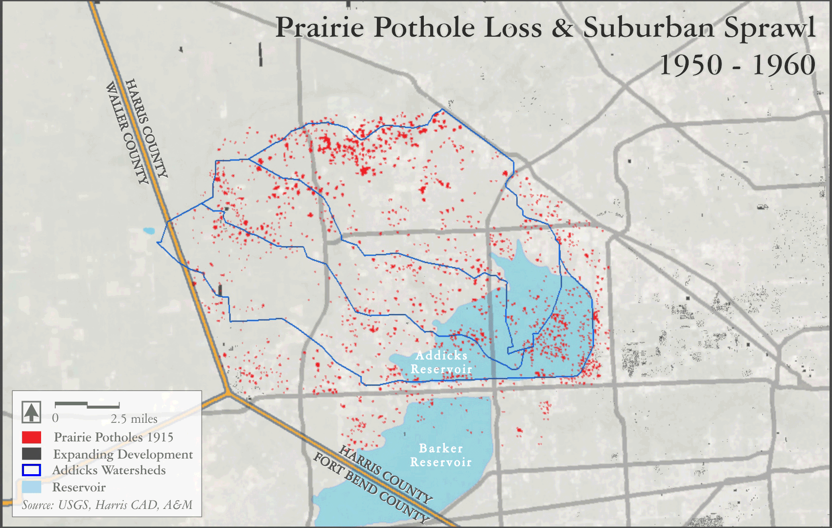
There are many pieces to the puzzle of Houston’s flooding problem, but one part is certainly the loss of the prairie potholes that once dotted much of the area landscape.
This animated map of the Addicks reservoir watershed may help describe the issue. Located about 19 miles west of Houston’s downtown, just north of IH-10, the 210,000 acre-foot reservoir was completed in 1948 with a rolled earthen dam over 5 miles long. The dam was built in tandem with Barker reservoir (located immediately south of IH-10), to protect areas in the Buffalo Bayou watershed downstream, especially Houston’s downtown, which had suffered a devastating flood in 1935.
Addicks reservoir, in conjunction with Barker, has worked extremely well in the years since, capturing enormous amounts of stormflow and storing it until the runoff can be slowly and safely released downstream. However, as Houston’s population has swelled, construction has spread out into the countryside surrounding the city core. A good deal of that construction, including homes, offices, stores, roads and parking lots, has found its way to the area upstream of Addicks reservoir.
Many of these building projects (shown in black) in the Addicks basin have regraded and/or paved over the prairie potholes, shown in red, that once peppered the watershed, as illustrated by depressions mapped in 1915 and 1916 by the USGS. Where those potholes once acted as natural detention ponds and infiltration sites, manmade impervious cover (shown here as improvement areas exceeding 50% of the lot size) now sits and rapidly sheds water downslope, quickly filling Addicks reservoir, and eventually contributing to high flows downstream.
Sources:
Gonzalez, Jaime. 2016. Community Conservation Director, Katy Prairie Conservancy. Personal communications, 13-20 May 2016.
Harris County Appraisal District. 2016. Real Property. http://pdata.hcad.org/download/index.html, accessed May 30, 2016.
Jacob, John, Kirana Pandian, Ricardo Lopez, Heather Biggs. 2014. Houston-Area Freshwater Wetland Loss, 1992-2010. Texas A&M University, Texas Coastal Watershed Program.
U.S. Geological Survey. 1915. Addicks 7.5’ quadrangle, 1:31,680 scale topographic map, Harris County, Texas.
U.S. Geological Survey. 1915. Cypress 7.5’ quadrangle, 1:31,680 scale topographic map, Harris County, Texas.
U.S. Geological Survey. 1915. Hillendahl 7.5’ quadrangle, 1:31,680 scale topographic map, Harris County, Texas.
U.S. Geological Survey. 1915. Katy 7.5’ quadrangle, 1:31,680 scale topographic map, Harris County, Texas.
U.S. Geological Survey. 1916. Satsuma 7.5’ quadrangle, 1:31,680 scale topographic map, Harris County, Texas.
U.S. Geological Survey. 1916. Swanson 7.5’ quadrangle, 1:31,680 scale topographic map, Harris County, Texas.