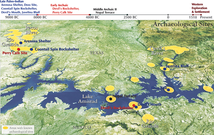
The Treaty of 1944 between the U.S. and Mexico authorized construction of three reservoirs along the Texas reach of the Rio Grande. One, Lake Amistad, was sited to the northwest of Del Rio, and completed in 1968 for water supply and flood control. As Amistad filled, over 1000 prehistoric sites, some as old as 11,000 years before the present, located in the river bed and steep cliffs of the Rio Grande, Devil’s River and Pecos River, were inundated.
Early digs dating to 1932, and salvage archeological work in the 1950s and 60s recovered over 1 million remains, including massive bison bones, beautiful cave drawings, elegant necklaces and pendants, and carefully worked tools and weapons, such as nets, scrapers, spear points and digging tools from these now-flooded sites.
Inundated sites have suffered from the flooding itself, as well as wave action from high winds and passing boats, fluctuations in Lake levels, tunneling by the Asiatic clam, and increased access and abuse by visitors.
Map source:
Dering, Phil. 2002. Amistad National Recreation Area: Archeological Survey and Cultural Resource Inventory. National Park Service by the Center for Ecological Archeology. Santa Fe, New Mexico.
Selected references:
Black, S. Bryant, V. and J. Labadie. 2008. Texas Beyond History: Before Amistad. The University of Texas at Austin. http://www.texasbeyondhistory.net/pecos/before.html (Accessed March 30, 2012).
Black, S. and J.P. Dering. 2001. Texas Beyond History: Lower Pecos Canyonlands. The University of Texas at Austin. http://www.texasbeyondhistory.net/pecos/index.html (Accessed March 30, 2012).
Labadie, J.H. 1999. Amistad National Recreation Area: A Cultural Resources Study. National Park Service, Southwest Cultural Resources Center. Santa Fe, New Mexico.