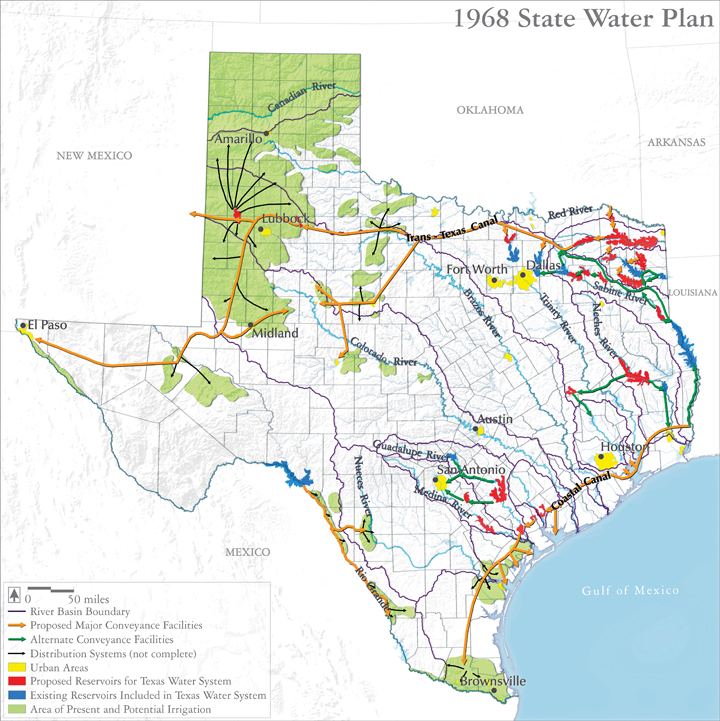
Texas Water Plan of 1968
The 1968 plan might be considered a “high-water mark” for efforts to move water around the state. Estimated to cost $14 billion in 1968 dollars, the Plan included two concrete-lined aqueducts, the Trans-Texas and Coastal Canals, fed by 62 new reservoirs, and powered by 12 nuclear plants generating 7 million kilowatts of electricity. The Trans-Texas Canal would have brought Mississippi River water 4000 feet uphill to Lubbock, and on to New Mexico and the Trans Pecos. The Coastal Canal would have delivered Mississippi River flows to the Rio Grande Valley, crossing four major rivers and 142 minor streams along the way.
However, funding the Plan would have required amending the Texas Constitution with a public vote, and Texans turned the Plan down by a narrow margin of 6000 votes, leading to a much more modest future for water transfers in Texas.
Audio:
Pete Gunter sings a Calypso tune lampooning the Texas Water Plan of 1968 –
Map source:
Texas Water Development Board. 1968. 1968 State Water Plan. http://www.twdb.state.tx.us/waterplanning/swp/1968/ (Accessed October 30, 2014).
Selected reference:
Votteler, T., Alexander, K., Moore, J. 2006. “The Evolution of Surface Water Interbasin Transfer Policy in Texas: Viable Options for Future Water, Water Grabs, or just Pipe Dreams?”, in Texas Environmental Law Journal.